Utility Location Mapping – Digging Below the Surface
April 23rd, 2021
There’s an old expression – “measure twice, cut once.”
The same general philosophy applies when it comes to utility location mapping. The days of digging blindly and hoping you don’t hit anything are over. This is risky practice as it can not only cause service disruption, but could also result in expensive repairs or severe injury.
We’re firm believers that underground utilities should be accurately and thoroughly documented – not only to support the construction of a specific project, but to guide future development on and around the site.
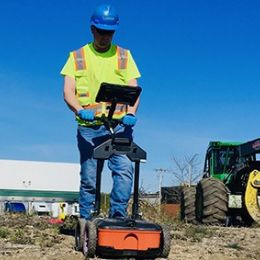
Non-destructive methods to identify the presence of underground utilities have grown increasingly popular as they offer efficiencies and advantages over traditional drilling, digging and testing methods. Loureiro’s underground utility locating specialists utilize the latest Ground Penetrating Radar (GPR) and Electromagnetic Induction (EMI) technology to efficiently provide the exact location and depth measurements of concrete pipes, drainage and sewer lines, electric and gas lines, fiber optic cables, and more. We are accredited (still in process) by National Utility Locating Contractors Association (NUCLA) and committed to meeting the organization’s training standards and delivery methodology.
GPR vs. EMI – what’s the difference?
Ground-penetrating radar (GPR) is a non-invasive, high-resolution geophysical locating method that utilizes high-frequency radio waves to detect structures below the subsurface. The method is particularly sensitive to variations in electrical conductivity and electrical permittivity (the ability of a material to hold a charge when an electrical field is applied). An electromagnetic pulse is steadily radiated into the ground from an antenna. When the radar signal encounters a change in permittivity, some of the electromagnetic energy is reflected back to the surface – indicating the likely presence of a utility or buried anomaly.
Electromagnetic induction measures the magnetic field around a utility system that is produced by a radio frequency. The radio frequency can be naturally occurring or induced with the use of a transmitting device. The magnetic field forms a cylindrical shape (or signal) around the conductor. These passive signals can arise from naturally present currents or can result from the use of a transmitter designed to produce an active signal.
Mapping Utilities on Projects
Loureiro is routinely tasked with utility mapping by construction managers, site contractors, municipalities, property owners and developers prior to breaking ground. Whether making simple improvements to a private residential property or embarking on the complex construction of a campus, it is important to make sure that the excavation area is free of utility systems.
State law generally requires the marking of public utilities to avoid impacts – think “Call Before You Dig” or “Dig Safe”. Public utility companies will locate the facilities they own (utilities that run meter to main specifically electric, gas, oil, sewer, telephone, and water). From there, private utility location, marketing and mapping services come into play.
Utility Location and Marking
Sometimes we’re called in to simply mark out the utility locations above ground. Our crews perform a thorough investigation of the area using a range of specialized equipment which enables buried utility location up to a maximum depth of 12’ and concrete scanning up to 24” deep. This important step confirms (or denies) information that is readily available on utility maps, which can oftentimes be outdated, incomplete or inaccurate. Using paint, we clearly mark out the locations so that excavation activities can proceed confidently.
3D Imaging
While we’re happy to perform basic utility location and marking services, some clients elect to supplement this project-specific need by opting for our 3D utility imaging services. We have the technology to tell the complete story – well beyond the high-level detail that we’ve marked out specific to the project at hand. We can provide comprehensive, high-quality mapping of all utilities existing below the surface. This is particularly beneficial for complex sites and campuses with pre-existing utilities and plans for future expansion. This add-value service leaves clients armed with an accurate picture of the underground utility infrastructure long after the paint markings wear off.
Call Loureiro before you dig, too.
We’ve got the technology and expertise so that you can avoid worrying about potential utility impacts. If you’re interested in getting a better handle on what’s going on below the surface, contact our Utility Locating team to ensure that your next project or development proceeds smoothly.
—
Sources:


